 Petra (lit. Rock) was the capital city of the Nabataeans, a tribe of pre-Roman Arabs who dominated the region around the Sixth century BC. Located at the crossroads of ancient trade routes, the city survived on toll and taxes collected from traders. Despite several attempts to conquer their capital, the Nabataeans remained practically independent until the defeat of Antony and Cleopatra and the reunification of the Roman Empire by Octavian in 31 BC. In 106, the Romans under Trajan finally captured Petra to mark the beginning of the decline of the city. The city remained unknown to the Western World for hundreds of years until a Swiss explorer, J.L. Burckhardt, heard about its existence from the local Bedouins in 1812. Petra (lit. Rock) was the capital city of the Nabataeans, a tribe of pre-Roman Arabs who dominated the region around the Sixth century BC. Located at the crossroads of ancient trade routes, the city survived on toll and taxes collected from traders. Despite several attempts to conquer their capital, the Nabataeans remained practically independent until the defeat of Antony and Cleopatra and the reunification of the Roman Empire by Octavian in 31 BC. In 106, the Romans under Trajan finally captured Petra to mark the beginning of the decline of the city. The city remained unknown to the Western World for hundreds of years until a Swiss explorer, J.L. Burckhardt, heard about its existence from the local Bedouins in 1812.
The initial identification of the site as a marketplacealong with the adjacent Middle Market' and Upper Market'was made by the German expedition of Bachman, Wiegand and Watzinger, who completed the first extensive mapping of Petra's city center (1921). Since no excavations were conducted at the time, however, these identifications were based primarily on their most prominent shared characteristiclarge, open, unbuilt areasand the expectation that a major entrepôt such as Petra would have a large centralized marketplace.
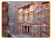
The Nabataeans carved their Capital in the canyons and hills of sandstone of Wadi Araba in Jordan. The entrance to the city is through The Alley (Al-Siq), a winding trail at the bottom of the canyon. Most famous is The Treasury (Al Khazneh), which fascinating façade was featured in many movies. Carved in the pink sandstone, the structure is 40 m high and about 30x30 m wide. Its architecture has been certainly strongly influenced by the Romans, which suggests it was built around the First century AD. The city includes other fascinating monuments and structures, such as Urn Tomb and the Royal Tombs, the Colonnade Street, the Temples of Dushara and Al-Uzza, and the High Place of Sacrifice.
During a two-month field season in the summer of 1998, a survey and excavation was conducted in the so-called Lower Market in order to determine its function, organization, historical development, and its relationship to the other monuments in the city's civic center. Work began with the creation of an accurate map of the topography by the project's surveyor, Paul Zimmerman, using the SiteMap surveying system, the computerized mapping system utilized by the Great Temple project (figs. 5 and 6). Relevant surface features and architectural components revealed through subsequent excavations were surveyed in and added to the overall
A monumental wall, 2.5 m high, runs east-west along the juncture between the quarry and the earthen terrace, bisecting the site (the pale line across the middle of fig. 3). The quarried area to the south of the wallwhich is bounded to the south and east by vertical escarpments, and to the west by the Great Temple's perimeter wallis filled with a deep deposit of earth, forming a plateau 2.5 m above the level of the earthen terrace. At the center of the plateau, the ruins of a rectangular structure are clearly visible at the surface
|